Aaaaaaaand, teh l33t MSPaint map of teh 0verw0r1d is compl33t:
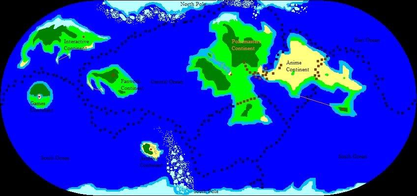
Key
Tan stuff is flat and barren: beach, desert, and wasteland.
Light green stuff is flat but not barren: grasslands and plains.
Dark green stuff is not flat or barren: forests and jungles.
Dark blue stuff is deep ocean water.
Light blue stuff around the continents and landmasses is shallow ocean water.
Off-white blue stuff at the north and south edges of the map is ice.
Navy blue squares are undersea mountains and valleys that divide the continental plates.
Brown squares are on-land mountains and mountain ranges.
Orange lines are bridges.
Lastly, red spots are the capital cities of each continent:
Pokemasters Capital: The Binary District
Games Capital: TBA (I haven't come up with one yet.)
Anime Capital: ASB
Fanwork Capital: Smiley Town
Interactive Capital: Twilight Town
Archive 'Capital': None (The red dot is the fortress they're stored in.)
The few things that have been named, as usual, are subject to change.
EDIT: Forget the compass, which is... uh... normal. What, did you expect the freaking map to be upside-down?
Also, the map is of the whole planet. Considering the tiny Archive island is about 150 miles across at its widest, it's safe to say this planet is pretty tiny. I didn't bother to measure it exactly, though, because nobody gives a shit how big it is. ...Or, at least I don't, anyway. d:


 Reply With Quote